

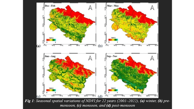
BENGALURU: Satellites observing the Himalayas have started reading the mountains like a slow-moving diary. Grasslands revive with the changing seasons, forests deepen in color, and patterns of valley flora change, but the same images also carry warnings of stress. Analysis of two years of data on Uttarakhand’s vegetation shows how closely the region responds to climate, and how those rhythms are starting to falter.Mountain ecosystems respond to changes in temperature and rainfall more quickly than most landscapes. Rising global surface temperatures and changing precipitation patterns are already affecting plant growth, soil moisture and snowpack. Scientists say local and long-term monitoring is crucial if governments are to prepare for floods, droughts and biodiversity loss.To track these changes, researchers at the Aryabhatta Institute of Observational Sciences (ARIES) in Nainital, an autonomous institute under the Department of Science and Technology (DST), worked with Indian and international collaborators, using Google Earth Engine (GEE), a platform for processing large amounts of satellite data. The tool enables scientists to study land degradation, urban growth, dust movement and temperature trends without the heavy burden of storing raw images.The team examined satellite records from 2001 to 2022 and relied on a widely used metric, the Normalized Difference Vegetation Index (NDVI). The index measures how well a plant reflects light and provides a simple guide to a plant’s health. Lower NDVI values indicate rock, sand, water, or snow, while higher values indicate dense forest, farmland, or wetlands. The researchers also looked at the Enhanced Vegetation Index (EVI), which performs better in areas with rich biomass.The findings, led by Umesh Dumka of ARIES and published in the journal Environmental Monitoring and Assessment, reveal clear seasonal cycles. NDVI and EVI peak after monsoon when hills become lush and fall to minimum levels before rainfall. Monthly and annual changes follow familiar patterns, but the long-term chart shows a gradual decline.The study linked the decline to deforestation, agricultural expansion, illegal logging and increased pollution in towns and industry. The researchers note that the effects of pollution are not uniform. Some areas suffered more severe damage, adding to stress from rising temperatures and erratic rainfall. This pressure threatens wildlife habitats, river systems and the livelihoods of millions of people who depend on the mountains downstream.Using time-series maps generated by GEE, the scientists compared vegetation trends with climate data and applied Pearson correlation coefficients to understand their relationships. This approach allowed them to pinpoint areas where greenness has been reduced the most.The authors argue that satellite science can serve as an early warning system. By identifying vulnerable areas, authorities can plan reforestation, regulate construction and control emissions before damage becomes irreversible. The Himalayas, they say, are sending signals of pain in the language of pixels and numbers. Listening to this message may determine the region’s ability to recover in the coming decades.
