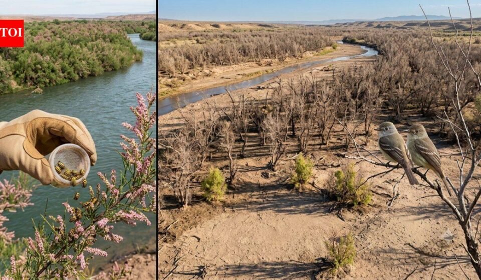
In 2001, scientists released the beetles to fight invasive trees. Years later, an endangered bird has lost 94% of its habitat along a western river | World News

The southwestern willow flycatcher’s breeding range spans thousands of kilometers of rivers and streams in the southwestern United States, but much of its habitat has long been difficult to assess in a consistent manner. Dense vegetation, changing river systems and seasonal droughts all make monitoring small migratory birds a complex task. A report from the U.S. Geological Survey provides a broader picture than the conservation agency has previously seen, pulling together satellite observations to map suitable breeding habitat across the bird’s range. The work gives land managers a way to monitor habitat changes over time while also helping them identify areas where emerging threats could have the greatest impact on one of the U.S.’s federally protected endangered birds.
Southwestern Willow Flycatcher Breeding Habitat and Conservation
The southwestern willow flycatcher is a small songbird that relies on dense riverside vegetation for nesting during the breeding season, which usually runs from May to September. It occupies riparian corridors in parts of the southwestern United States and relies on healthy shrubs and trees growing alongside rivers and streams.Its conservation has been a long-standing priority under the Endangered Species Act. In 2013, the U.S. Fish and Wildlife Service identified nearly 1,975 stream kilometers of critical habitat across six states and 38 counties. Protecting such a vast and fragmented landscape remains difficult because droughts, floods, vegetation changes and human activities can cause conditions to change from year to year.The USGS report attempts to close this gap by using satellite-based models to examine breeding habitat across the species’ distribution, rather than relying solely on local field surveys.
How satellite mapping tracks changes in flycatcher habitat
Rather than focusing on individual nesting sites, satellite models assess vegetation patterns across entire watersheds. This allows scientists to identify places that may support flycatcher breeding and observe how these areas expand or contract over successive years.According to the report, year-to-year climate differences leave a noticeable impact on available habitat. During a severe drought from 2013 to 2015, suitable habitat was reduced in parts of California. Meanwhile, conditions have improved in parts of New Mexico and Texas, illustrating how regional weather patterns can reshape breeding opportunities across the bird’s range.The method also provides conservation agencies with a consistent way to compare landscapes spread across multiple states, something that has previously been difficult using field observations alone.
In 2001, an introduced beetle posed unexpected conservation challenges
The report examines another issue affecting the species: the spread of the tamarisk leaf beetle.The insect was intentionally introduced by the U.S. Department of Agriculture’s Animal and Plant Health Inspection Service in 2001 as a biological control method for invasive tamarisk trees. Tamarix, sometimes called salt cedar, has spread widely along rivers and streams in the western United States, replacing many native plants and altering river ecosystems.Since its initial release at ten sites in six western states, the beetle has spread far beyond its original range. They are currently established in parts of the Colorado River Basin, parts of the lower Colorado River in Arizona, and parts of the Rio Grande River in New Mexico.While reducing invasive tamarisks has environmental benefits in many places, the relationship with flycatchers has proven more complex.
Why Tamarix is important to flycatchers
Although tamarisk is not native, many southwestern willow flycatchers have adapted to nesting in mature forests where native streamside vegetation has been lost. When beetles strip trees of leaves during the breeding season, the nests are exposed to higher temperatures and predators.Satellite models highlight how severe these impacts could become in some river systems. The report estimates that habitat suitable for flycatchers declined by about 94 percent along the lower Virgin River between 2010 and 2015, leaving only a small portion of the original habitat.Looking ahead, the model suggests that if the beetle continues to spread, populations may decline further. The lower Colorado River could lose about 36 percent of its habitat over the next decade, while the upper Gila River could lose about 55 percent of its suitable breeding habitat under projected conditions.
Help conservation managers decide where to take action
The mapping system is designed to support actual management rather than simply documenting habitat loss.By identifying areas most vulnerable to future beetle activity, agencies can decide where restoration efforts are likely to provide the greatest benefit. Current efforts include removing invasive tamarisk wherever possible, restoring native streamside vegetation and planting native habitat on land previously used for agriculture.The long-term effectiveness of these programs remains uncertain. Even so, having landscape-scale maps of habitat allows managers to prioritize sites before conditions worsen, rather than reacting after breeding areas have been lost.The model also provides a way to monitor whether restoration efforts create new habitat that can support future flycatcher populations.
A collaborative effort among federal agencies
The report was a collaboration between the U.S. Geological Survey, the U.S. Fish and Wildlife Service and the U.S. Bureau of Reclamation.In addition to mapping existing habitat, the project combines information on vegetation and beetle expansion to estimate changes in breeding areas over time. This provides wildlife agencies with another source of evidence when planning conservation actions, evaluating restoration projects, and meeting obligations to protect habitat associated with federally listed endangered species.